State of Our Broad & Green River Basins

About the Broad & Green River Basins
The Broad River originates close to the Eastern Continental Divide in the mountains of western North Carolina and tumbles down the Blue Ridge Escarpment, then flows southeast through the foothills and Piedmont before entering South Carolina. Major tributaries include the Green, First Broad, Second Broad, and North Pacolet rivers. There are also four major man-made lakes, including the popular tourist destination Lake Lure, built in 1926. Other reservoirs include Lake Summit, Lake Adger, and Kings Mountain Reservoir, also known as Moss Lake.
Upstream of Lake Lure, the Rocky Broad is very clean, although it does pass through residential areas and the Town of Lake Lure before it reaches the lake. Below Lake Lure, the mountainous terrain along the river transitions into rolling foothills with wider valleys and rich bottomlands more suitable for agriculture.
The Green River is the largest tributary of the Broad River in North Carolina, and its headwaters are largely protected. As the river flows from its source in Henderson County to Lake Summit, it is impacted by agriculture, poor stream management practices, and a lack of appropriate riparian buffers. At Lake Summit, water is released downstream into the Green River Gorge, where the river receives additional flow from its confluence with the Big Hungry River. The Green River benefits from protected land as it travels through the Green River Game Lands and drops steeply down the Green River Narrows — a world-renowned whitewater paddling destination — before settling into Lake Adger in Polk County. The Green River flows into the Broad River near the Polk and Rutherford County Line. Major tributaries in the lower Green River Watershed include Walnut Creek from the north and White Oak Creek from the south.
The Broad River converges with the Second Broad River upstream of the Rutherford and Cleveland County Line. Originating in the foothills of the Blue Ridge Mountains near Marion, the headwaters of the Second Broad quickly flow into the agriculture-rich Piedmont region near the towns of Rutherfordton, Spindale, and Forest City. Industry becomes more prominent as the Broad River flows east from Rutherford to Cleveland County.
The First Broad River's clean headwaters originate in the protected South Mountain Game Lands. The headwaters of the First Broad, including the North Fork (a designated Outstanding Resource Water), trickle down the south side of the rugged mountains. With peaks just under 3,000 feet and valleys thick with rhododendron and hemlock, these woodlands were saved from logging by residents in the basin, public and private conservation groups, and state government officials. Without this intervention, erosion caused by logging could have impaired water quality in a watershed that supplies drinking water for the City of Shelby and Cleveland County. The N.C. Wildlife Resources Commission now manages the 17,829-acre tract as the South Mountains Game Lands, which is adjacent to NC’s largest state park, the 20,000-acre South Mountains State Park.
Water quality declines as the First Broad enters the agriculture-rich Piedmont region, where cattle are often allowed to roam into local streams. There are over 100 industrial chicken operations in Cleveland County (most of which are in the First Broad River sub-basin) that apply large quantities of manure as crop fertilizer. Without adequate fencing and riparian buffers, agricultural runoff catalyzes erosion and increases turbidity and bacteria pollution. The First Broad River eventually meets the Broad River before flowing into South Carolina.
Overall, water quality in the basin is good, but habitat degradation, development, and stormwater runoff are increasingly impacting water quality. Stream habitats become stressed due to runoff from construction sites, residential areas, cropland, pastures, and paved areas that don’t allow water to soak into the soil. Stormwater transports eroded soil, fertilizer, and animal waste into surrounding waterways. Due to development pressures, there is also the need for efficient municipal wastewater treatment in the Broad River Basin, as well as properly constructed and maintained septic systems.
Swim Guide E. Coli Bacteria Analysis
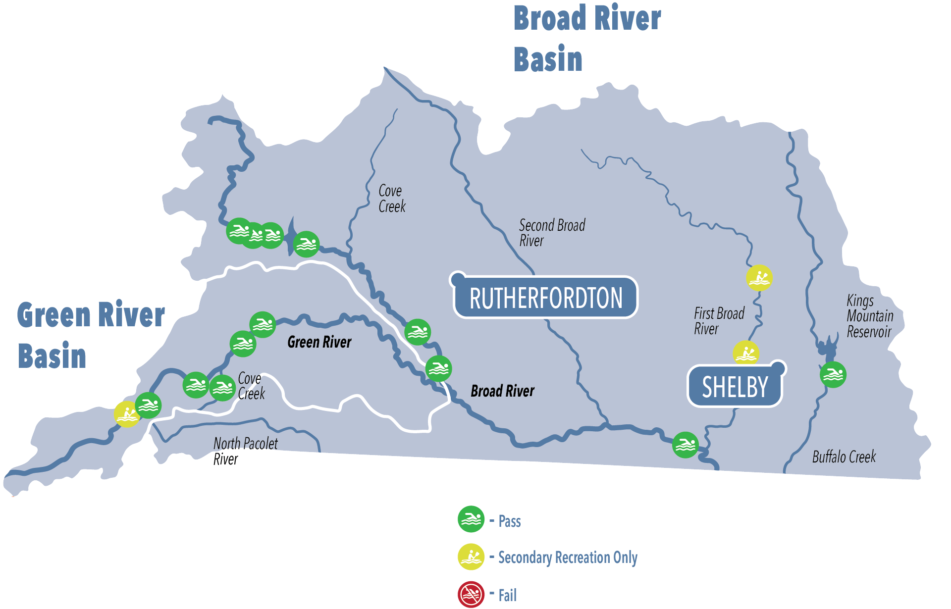
Overall, the Green and Broad Rivers showed relatively low levels of bacterial pollution. As we observed in watersheds throughout our region: more remote areas were generally cleanest and passed the EPA safe swimming standard. On the other hand, we were more likely to observe higher levels of bacteria pollution in waters closest to urban development and high concentrations of agricultural operations.

The Green River is one of the cleanest basins in MountainTrue’s service area, and most of the recreation sites that we tested regularly passed the EPA safety standard for primary recreation — such as swimming, tubing, and other activities where the head is likely to get submerged and ingestion of water is possible. Indeed, the Upper Green Put-in Access and Lake Adger Marina were among the cleanest sites in the Broad River Watershed. The Big Hungry sampling site was the only site on the Green River to fail the stricter safe swimming standard regularly, but it still usually passed the standard for secondary recreation activities like paddling, where accidental water consumption is less likely. Here, the public should swim with caution, checking the latest Swim Guide results and forgoing swimming after heavy rain when the water is visibly muddy.
The cleanest site in the Broad River Basin was the Moss Lake/Kings Mountain Reservoir site at Camp Creek Church Rd. Picnic Area and sites along the mainstem of the Broad River were generally very clean, passing the EPA safety standard for swimming. However, the two sampling sites on the First Broad River, including the Grover Street sampling site in Shelby, failed the swimming standard and, on average, only passed the standard for secondary recreation.
Total Samples Collected: 220
Average E. coli across all sites 160.1 MPN/100 mL
15% of sites sampled failed to meet EPA recreational standards
Broad River Watershed: 177 MPN/100 mL across 150 samples.
Green River Watershed: 122.4 MPN/100 mL across 70 samples
Cleanest Swim Guide Sites (Average E. coli):
- Moss Lake at Camp Creek Picnic Area - 8.2 MPN/100 mL
- Upper Green Put-in Access - 18.6 MPN/100 mL
- Lake Adger Marina - 43.5 MPN/100 mL
Dirtiest Swim Guide Sites (Average E. coli):
- First Broad at Grover St - 369.9 MPN/100 mL
- First Broad at Double Shoals - 359.1 MPN/100 mL
- Big Hungry River - 281.4 MPN/100 mL
Stream Health Analysis
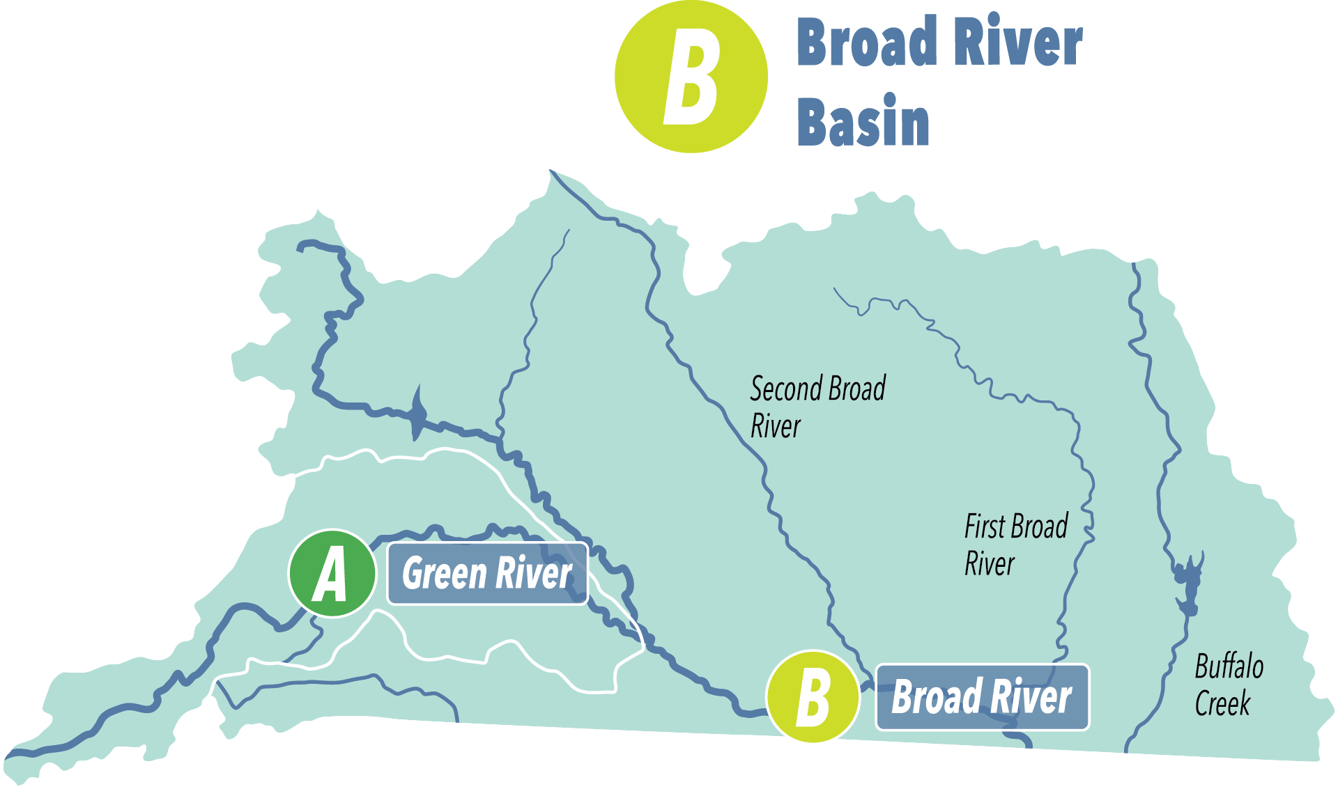
The Broad River Basin received an overall grade of Good (B), with the Green River receiving an overall grade of Excellent (A). The results suggest better stream health in the largely protected Green River Basin compared to the Broad River — which is more heavily impacted by agriculture and development.

How We Grade
A (90-100) - Excellent
Streams with excellent water quality, low pollution levels, and healthy aquatic insect and fish populations.
B (80-89) - Good
Streams with good water quality but some impacts from pollution or development. Aquatic life and fish populations were relatively healthy.
C (70-79) - Good-Fair
Streams with average water quality. There are some concerns about pollution inputs and development impacts. Generally, aquatic life and fish populations were healthy but could become negatively impacted in the future.
D (60-69) - Fair
Streams with below-average water quality. Pollution is a concern, and aquatic life and fish populations were not as healthy as they should be.
F (<60) - Poor
Streams with poor water quality. Pollution levels were often high, and aquatic life and fish populations were impacted.
Stream Health Results by Tributary
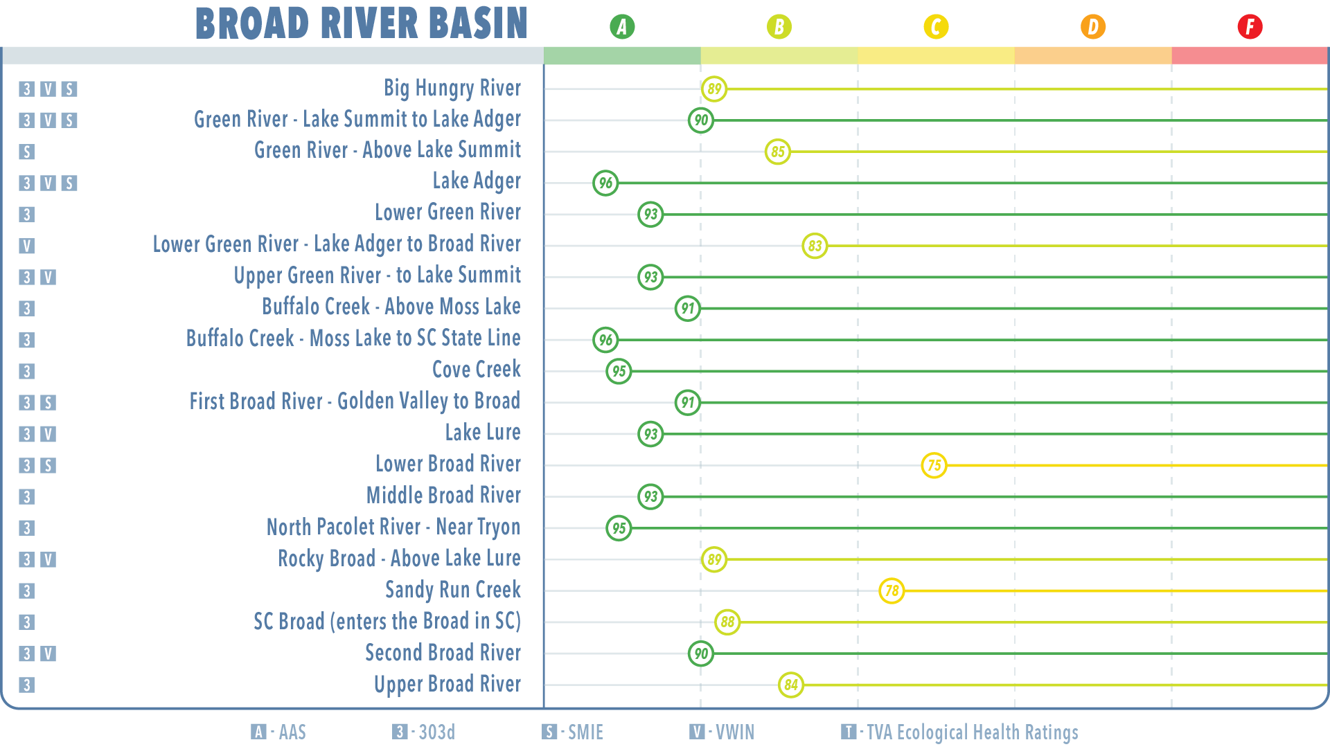
The Broad River Basin ended the year with fairly high Stream Health grades. Lake Adger and Buffalo Creek - Moss Lake to SC State Line had the highest scores in the basin of 96, indicating Excellent (A) stream health. The Lower Broad River held the watershed’s lowest score of 75 or Good-Fair (C). Across all testing sites, the Broad River Basin had an average score of 89, which puts it on the high end of the range of Good (B).

