
Executive Summary
MountainTrue’s State of Our Rivers report combines a year’s worth of data collected by its staff and volunteers with other publicly available datasets to provide readers with a deeper understanding of the health of our rivers, lakes, and streams. For the first time, this report identifies likely environmental factors impacting our river basins and targeted policy solutions that, if adopted, would protect the health of our communities, aquatic ecosystems, and water-based recreation economy.
The State of Our Rivers provides two sets of analyses for each watershed. The first is our Swim Guide E. Coli Bacteria Analysis, which utilizes samples collected from popular recreation sites throughout our mountain region from Memorial
Day through Labor Day weekends. Throughout these 15 weeks in 2022, MountainTrue staff and volunteers collected and analyzed 1,167 samples from 90 locations. The second, our Stream Health Analysis, combines data from multiple sources to gauge how well a stream or river supports aquatic life. Read more about our methodologies.
The following are the key takeaways from the 2023 State of Our Rivers report:

The French Broad River is generally unsafe for swimming and other primary recreation.
Across our region, we saw that our most polluted waterways are those closest to and most impacted by urban development and agriculture. Nowhere is that more true than the French Broad Watershed, which hosts many of our region’s most popular recreation areas. In 2022, the NC Department of Environmental Quality added a 19-mile section of the French Broad River — stretching from Arden to Woodfin through Downtown Asheville — to its list of impaired waterways due to higher levels of bacteria pollution.
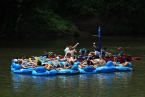
Tubers enjoying a day on the French Broad River. Photo courtesy of Andolent (FLICKR)
Our report shows that the problem is more widespread — nearly the entire lengths of the French Broad and Swannanoa rivers regularly tested above the EPA’s safe swimming standard. The EPA measures bacteria pollution in the most probable number (MPN) of E. coli bacteria colony forming units per 100mL of water and has set a limit of 235 MPN/100mL for safe primary recreation — such as swimming, tubing, and other activities where the head is likely to get submerged and ingestion of water is possible.
Testing sites in the Middle French Broad, which flows through Asheville and Marshall, NC, had an average E. coli level of 1922.8 MPN/100mL, or eight times the EPA swimming standard. The Upper French Broad, which passes through Brevard, NC, was only marginally better, with an average E. coli concentration of 607.6 MPN/100mL. The Lower French Broad, which flows through Hot Springs, NC, was the least polluted section of the watershed; however, it still often failed the safe swimming standard and, on average, only passed the more lenient safety standard of 406 MPN/100mL for secondary recreation activities like paddling, where accidental water consumption is less likely.
While other watersheds provide safer recreation opportunities, even our cleanest watersheds are impacted by pollution.
The watersheds in other parts of MountainTrue’s territory were much less impacted by pollution than the French Broad. However, even in our cleanest watersheds, we still saw higher bacteria levels in areas closer to urban areas, development, and farms.
For example, the Hiwassee River was the cleanest river within our service area for the 2022 Swim Guide season with an average E. coli measurement of 71.1 MPN/100 mL across 105 samples, and the wider basin was the second cleanest with an average of 207.2 MPN/100 mL across 194 samples. However, sites on the Valley River regularly failed the EPA safe swimming standard due to failing septic systems and inadequate sewer infrastructure in and around the Town of Andrews, as well as poor pasture management and livestock practices throughout the watershed.
The testing site on the Nottely River at Meeks Park II only passed the EPA swimming standard when the lake was completely full. Most of the time, it only met the standard for secondary recreation activities like paddling. The same goes for the Hiwassee River at Sweetwater Park, which is impacted by cattle operations along Sweetwater Creek that have heavily eroded streambanks and lack livestock fencing and riparian buffers.
We observed the same pattern in the Broad, Green, Elk, New, and Watauga rivers: more remote areas were generally cleanest and passed the EPA safe swimming standard. Rivers and streams closest to urban development and high concentrations of agricultural operations were most likely to fail both standards for swimming and secondary recreation, while those further from town and farms were more likely to pass the EPA standard for secondary recreation.

Clean Waters are Critical to our Outdoor Economy
The Southern Blue Ridge Mountains are renowned for their beautiful vistas and winding rivers, which are treasured by residents and attract vacationers looking to experience the great outdoors.
$11.8 billion - Economic Activity Generated by Outdoor Recreation in NC
US Dept. of Commerce’s Bureau of Economic Analysis
$383 million - Mountain Trout Fishing’s Impact on NC’s Economy
NC Wildlife Resources Commission
$38 million - Spending Generated by Paddlers Visiting Nantahala & Pisgah National Forests
Outdoor Alliance
Stream Health is generally Good, with the Green River enjoying Excellent Stream Health.

For our Stream Health Analysis, we looked at a broad set of environmental factors to gauge impacts from fertilizer, pesticides, sediment pollution, and road salts. This allows us to measure the health of aquatic habitats and how hospitable a body of water is for supporting a diversity of aquatic species.
We scored stream health on a scale of 0-100 and gave streams the following grades:
A (90-100) - Excellent
Streams with excellent water quality, low pollution levels, and healthy aquatic insect and fish populations.
B (80-89) - Good
Streams with good water quality but some impacts from pollution or development. Aquatic life and fish populations were relatively healthy.
C (70-79) - Good-Fair
Streams with average water quality. There are some concerns about pollution inputs and development impacts. Generally, aquatic life and fish populations were healthy but could become negatively impacted in the future.
D (60-69) - Fair
Streams with below-average water quality. Pollution is a concern, and aquatic life and fish populations were not as healthy as they should be.
F (<60) - Poor
Streams with poor water quality. Pollution levels were often high, and aquatic life and fish populations were impacted.
Within each watershed, we saw some variability. Every watershed had at least one site with Excellent (A) stream health, but overall, we found that waters throughout our region were in the range of Good (B) to Good-Fair (C).
 The Green River Watersheds had the best overall stream health in our region, with the highest percentage of rivers and streams with Excellent (A) grades. The only testing site in our mountain region to receive a Poor (F) grade was, unsurprisingly in the French Broad Watershed. That site, Newfound Creek, is heavily impacted by long-term agricultural activities. However, the French Broad River Basin, overall, had Good (B) stream health with Cataloochee Creek, which flows through Great Smoky Mountain National Park into the Pigeon River, having a perfect score of 100.
In the Hiwassee River Basin, Apalachia Lake, Fires Creek, and Hiwassee Lake scored 100; an additional nine stream and river sites earned grades of Excellent (A). Though the Hiwassee River Basin had Good (B) overall stream health, six streams — Butternut Creek, Ivylog Creek, Fodder Creek, Little Brasstown Creek, Mission Branch, and Youngcane Creek — suffered Fair (D) water quality and will require additional monitoring and water quality interventions.
In the Watauga, the cleanest streams were tributaries of the Elk River (a watershed within the Watauga River Basin) with a stream health grade of 90, which put it just on the edge of Excellent (A). The other three waterways all received Good (B) stream health grades.
Sources of pollution are not a mystery.
Many of the headwaters of our rivers are in protected forests and public lands. Therefore, our rivers generally are pristine at their sources but become more polluted as they wind through more developed areas. The main culprits of poor water quality are:
Poor Agricultural Practices
Farmers grow the food that sustains us, and their work is critical to ensuring the future food security of our region. However, poor agricultural management practices can spoil water for downstream neighbors. Inadequate livestock fencing and riparian buffers contribute to bank erosion and more stormwater runoff that carries bacteria and other pathogens, sediment, pesticides, and nitrogen-rich fertilizers into our waterways.
Overuse of fertilizers can result in the excessive growth of plants, lowering the amount of dissolved oxygen available to aquatic life and ultimately leading to fish kills. Excess nutrients in water bodies also contribute to algal blooms, some of which can release toxins harmful to human and animal health.

Failing Sewer, Wastewater, and Septic Systems
Our region’s stormwater and sewer infrastructure, septic systems, and wastewater treatment plants were built for smaller populations and haven’t been updated in tandem with population growth or increased rainfall due to climate change.
Wastewater treatment plants with inadequate carrying capacity more frequently overflow untreated sewage into area surface waters. Heavier and more frequent rain storms cause stormwater to enter and spill from leaking sewer pipes. And property owners who rely on septic systems can experience failures that contaminate surface waters, groundwater, and nearby wells.

Poorly Managed Development and Sprawl
According to projections by NC’s Office of State Budget and Management and Georgia’s Office of Planning and Budget, our region’s population will grow by more than 200,000 people, or 15.65%, between 2020 and 2050. How we accommodate our new neighbors will have dramatic effects on water quality.
Historically, local governments have been resistant to land-use planning, which has led to sprawl — the process in which the spread of development outpaces population growth. This low-density development devours our open spaces, farmlands, and forests. It leads to fewer trees, more construction, and more impervious surfaces like parking lots, roads, buildings, and other structures. Stormwater glides off these hard surfaces and poorly managed construction sites, mixing with sediment, nearby litter, and other pollutants before spoiling local waterways.

Our Changing Mountain Climate
Climate change will profoundly affect our region and exacerbate the abovementioned threats. More rain results in more stormwater runoff, flushing pollutants from impervious surfaces and poorly managed farms into our waterways.
Heavier, more frequent storms and flooding will erode poorly constructed gravel roads, cause more landslides, and overwhelm faulty septic systems and already inadequate municipal wastewater and sewer systems. Hotter weather creates a more hospitable environment for invasive plant and animal species, making protecting our natural heritage and economy more difficult and costly.

Community health and economic risks require policy interventions.
State and local governments have rightfully invested significant resources into our region’s tourism and outdoor recreation economy. Our rivers, lakes, and streams are valuable public resources that provide recreation and fishing opportunities for residents and draw visitors from around the world.
To protect these investments and the livelihoods of business owners, workers, and residents, lawmakers should:
Increase funding to help farmers improve water quality.
MountainTrue supports expanding state funding for local Soil and Water Conservation Districts (SWCDs) to meet the current demand from farmers who want to make improvements to reduce water pollution. Due to the severity of the bacteria pollution in the French Broad Watershed and data showing cattle as a primary source, at least $2 million should specifically be allocated to SWCDs in the French Broad through the existing Agricultural Cost-Share Program for livestock operation improvement projects.
Regulate industrial poultry operations appropriately.
Industrialized poultry growing operations are prevalent in the Broad River Watershed and have expanded significantly in recent years. These Concentrated Animal Feeding Operations (CAFOs) are “deemed permitted” by law and can be constructed and operated without scrutiny from the public, local governments, or environmental regulatory agencies. Because poultry CAFOs generate a tremendous amount of waste and contribute to bacteria and nutrient pollution in local waterways, they should be regulated under a permit system like other CAFOs to provide regulatory oversight and transparency.
Increase Funding for Septic System Repairs.
Fixing and maintaining a properly functioning septic system can be prohibitively expensive. MountainTrue has partnered with the NC Department of Health and Human Services to provide grants to repair failing septic systems to property owners with financial hardship in priority watersheds impacted by bacteria pollution. We support expanding these funding opportunities on the local and state levels to assist more property owners in need and protect water quality.
Heighten Enforcement and Funding to Prevent Sanitary Sewer Overflows (SSOs).
When municipal sewer systems are inundated with stormwater or do not have the capacity to handle the amount of waste generated, they overflow into nearby waterways, causing spikes in bacteria and nutrient levels. MountainTrue has worked with the NC Department of Environmental Quality (DEQ) to improve how SSOs are tracked and reported to the public. We also support more diligent enforcement and funding for infrastructure and municipal sewer upgrades.
Help property owners reduce stormwater pollution.
The Community Conservation Assistance Program (CCAP) allows WNC’s Soil and Water Conservation Districts (SWCDs) to help property owners reduce stormwater pollution in impaired waters. Like the cost-share program for farmers, funding for CCAP assistance is insufficient to meet demand. A good start would be to provide WNC SWCDs with $500,000 for the CCAP program to significantly reduce stormwater pollution in rivers and streams already impacted by bacterial pollution.
Invest in infrastructure improvements to accommodate increasing stormwater.
Climate change is causing more frequent and intense rain events. Municipal stormwater systems need to be upgraded to account for more water and should incorporate more green infrastructure to promote infiltration to groundwater aquifers instead of direct conveyances to surface waters, which can increase stream volume and velocity, exacerbating flooding and bank erosion. We support maximizing investment in infrastructure upgrades to accommodate increasing amounts of stormwater.
Enact policies and programs to require and incentivize the protection of riparian buffers.
Maintaining a vegetated riparian buffer is one of the best ways to protect water quality. In North Carolina, there are construction setbacks in some instances but no requirements to maintain vegetated buffers. That allows for shallow-root grasses on manicured lawns or plowed fields all the way up to stream banks, resulting in erosion, bank failure, and excess sediment pollution of streams. By contrast, Georgia has more robust statewide stream buffer regulations. North Carolina should follow suit.